


I thought I knew what the Brazilian Amazon would look like. In my mind, it was a postcard of mirror-flat water, trees standing ankle-deep in chocolate-brown river and a canoe sliding silently between trunks draped with orchids. The reality turned out to be more complicated. Over two trips, one during extreme high water on the Rio Negro near Manaus and another during relatively low water on the Tapajós near Santarém and Alter do Chão, I discovered that the “same” rainforest can feel like two different destinations depending on river level.
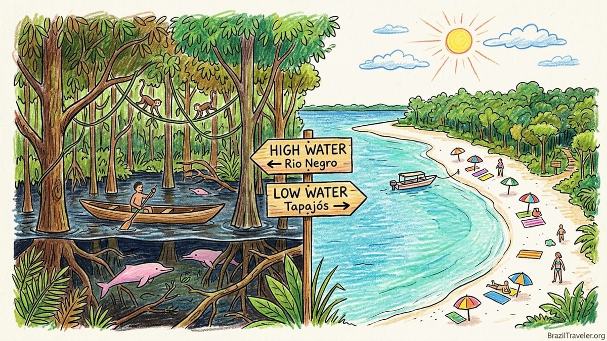
The Amazon I Imagined Versus the Rivers I Met
Before my first trip I planned purely around the words “dry season.” Most guidebooks still describe June to November as drier and better for hiking, and December to May as wetter and better for canoeing. I assumed that if I avoided the peak of the rains, the forest would match the promotional photos: wooden walkways hovering over flooded forest, pink river dolphins in still blackwater, and a few days of dramatic but manageable tropical showers.
That assumption ignored one critical fact. In the Amazon, river levels respond not just to the rain falling on your head, but to months of rain falling thousands of kilometres across the wider basin. Hydrologists describe a flood pulse that lags behind local rainfall. On the Rio Negro at Manaus, long-term records show that the river commonly peaks around May to July and reaches its lowest levels between October and December, often fluctuating more than 10 metres between extremes. That annual pulse can now be tracked day by day through the river-level graph published by the Port of Manaus, which I checked almost obsessively before and during my visit.
For the Tapajós basin, which drains large areas of central Brazil before reaching Santarém, the pattern is similar in principle but different in timing and amplitude. Technical reports on the Tapajós basin indicate an average annual fluctuation of roughly 4 to 5 metres near its mouth, with high water typically around May or June and more moderate low-water periods than the Rio Negro. Locals in Alter do Chão often summarise this as “full river” from about March to June, and “beach season” from roughly August to November, though recent years have seen noticeable shifts due to droughts and anomalous floods.
In other words, the photos that sold me on an Amazon holiday were all real, but they were not all taken in the same month or even in the same part of the basin. To experience flooded igapó forest, broad river beaches and deep rainforest trails in the same way the cameras did, I would have to start thinking in terms of river levels as much as rainfall.
My High-Water Rio Negro Visit Around Manaus
My first immersion came on the Rio Negro near Manaus. I chose late June for that trip after checking the historical Manaus gauge and seeing that water levels usually peak in June and start to recede in July. In the week I arrived, the official river bulletin showed the Rio Negro holding just below one of its recent record highs, part of a trend that has seen several of the ten highest floods of the last century occur within the last decade. On local dock walls, fresh paint marked the years 2012 and 2021 as exceptional floods, with my visit only slightly below those lines.
That height translated into an otherworldly landscape. From a small lodge reachable by fast boat from Manaus, we stepped directly from the reception deck into a wooden canoe. The terra firme forest behind the lodge was inaccessible because its trailheads and boardwalks were under several metres of water. Instead, we paddled through igapó forest, where the blackwater carried us silently among tree trunks. Leaves and orchids brushed our shoulders and the hull knocked gently against submerged branches. At one point, a troop of squirrel monkeys crossed overhead on lianas no more than two metres above our heads. The entire understory had become a navigable maze.
Wildlife-watching on the Rio Negro at this height felt intimate but diffuse. Many mammals had retreated to unflooded higher ground, often kilometres away from the river margin, while birds perched in the mid canopy. We saw sloths stranded on small emergent trees and macaws flapping between scattered crowns. River dolphins surfaced in the flooded margins, taking advantage of new foraging territory. Our guide explained that fish spread out into the forest to feed on fruits during high water, which meant dolphins and some birds did the same. Spotting individual animals took patience, but the sensory overload of being inside a semi-submerged forest more than compensated.
Comfort was a mixed bag. June brought oppressive humidity, with daytime temperatures in the lower 30s Celsius and air that felt completely saturated. Sudden afternoon storms rolled across the Rio Negro, dumping torrents of rain that drummed so loudly on the lodge roof we had to pause conversations. Mosquito pressure near the blackwater itself was lower than I expected, which local biologists attribute in part to the low nutrient content of Rio Negro water, but the moment we tied up at small creeks with slower flow the insects found us. Long sleeves and repellent became non-negotiable. Transport, however, was effortless. Boats could reach floating houses, lodge decks and community piers directly, so boarding was usually level with the dock and required minimal climbing.
My Lower-Water Tapajós Journey to Santarém and Alter do Chão
My second comparative trip focused on the Tapajós region, using Santarém as an entry point and the river village of Alter do Chão as a base. This time I wanted the opposite experience: broad river beaches, walkable trails and a clearer sense of the forest’s terrestrial structure. After reading regional studies that showed the Tapajós near Santarém generally reaching high water in May or June and lower levels by September to November, I booked for the second half of September.
When I arrived in Santarém, local news bulletins and municipal environment updates were discussing how the 2023 drought and the subsequent 2024 dry season had left river levels below the long-term average, though not quite at the record lows recorded during previous extreme drought years. On the waterfront, the clearwater Tapajós had pulled back to expose pale sandbars, and in Alter do Chão the famous Ilha do Amor sandbank was a continuous crescent of white sand fringed with beach bars, something that residents told me is impossible during the March to June high-water months when the sand all but disappears under water.
This low to moderate level changed everything about my daily rhythm. Instead of canoeing between tree trunks, I took small motorboats to reach trailhead landings in protected forest areas across the river, then spent hours hiking on dry ground under towering Brazil nut, itaúba and andiroba trees. On the Tapajós, the proportion of seasonally flooded forest is lower than on the Rio Negro, which meant many of the paths remained usable once the main flood had receded. Our guide pointed out the high-water mark on tree trunks, often 3 to 4 metres above our heads, to illustrate how completely our current trail would disappear a few months earlier.
Wildlife encounters shifted as well. On some dawn walks we spotted tracks of peccaries and tapirs on the damp sand of small igarapés, signs that heavier mammals were more active in these terrestrial corridors once they had re-emerged from floodwaters. Birdlife concentrated along the forest edge and at fruiting trees. River dolphins still worked the main channel, but the drama here belonged to humans reclaiming the beaches. Families from Santarém set up umbrellas and coolers on weekend afternoons, and beach kiosks grilled fresh tucunaré and tambaqui. Swimming in the clear, relatively warm Tapajós, away from boat traffic, became an everyday pleasure in a way it never quite was on the Rio Negro during my high-water visit.
Comfort trade-offs felt significant. September days remained hot, often above 32 degrees Celsius, but humidity was slightly less suffocating and rainstorms were shorter and more localised. On several days I enjoyed long, uninterrupted hikes without any downpour. Insects were persistent around forest edges and at dusk in the village, but breezes on the open beaches helped a lot. The main nuisance came from boat noise as small ferries and day-trip launches threaded between sandbars to reach popular stretches of sand. On certain afternoons, the whine of outboard motors was the soundtrack that replaced the drumming of rain from my Rio Negro memories.
How Rainfall, Wet Seasons and River Levels Actually Interact
The contrast between my two trips underscored an essential point for travel planning. The terms “wet season” and “dry season” in the Amazon can be misleading when they are not clearly connected to river levels. In both the Rio Negro and Tapajós basins, scientific analyses of long records show that rainfall tends to peak earlier than river height. For the Rio Negro, the highest rainfall typically comes in the months around March to May, while the river at Manaus often peaks in May to July and only reaches its lowest point between October and December. Studies of past droughts demonstrate this lag explicitly, showing that rainfall anomalies during the wet season translate into river anomalies several months later.
On the Tapajós, hydrological work on the basin and monitoring near Santarém indicate a similar delay. Heavy rains in the upper basin, which can begin in late southern spring, feed tributaries and gradually raise the main river, with the highest levels near the mouth usually recorded in May or June. River levels then decline into the austral spring, exposing beaches and islands. The magnitude and exact timing vary from year to year, and recent decades have seen extreme floods and droughts that depart sharply from the old patterns.
This distinction between rain and river is central to understanding why a shower in town tells you little about whether your igapó canoe excursion will run. On my Rio Negro trip, I experienced several days of intense, short-lived storms even as the river gauge showed the first millimetres of decline from its seasonal maximum. On the Tapajós in September, I had mainly sunny days with only light showers while the river remained low. If I had planned solely around local precipitation charts labelled “rainiest months,” I would have mis-timed the high-water forest navigation I wanted or missed the beach season entirely.
For travellers, the practical tool is river-level data, not just rainfall averages. The Port of Manaus publishes daily readings for the Rio Negro that show not only the current height but also comparisons with historical highs and lows. Local authorities and research agencies as well as regional tourism organisations around Santarém track the Tapajós in a similar way, often sharing graphs that highlight whether the current year is trending toward an unusually high flood or a concerning drought. Checking these resources in the months leading up to a trip gives a much clearer indication of what you will actually see on arrival than relying on “December equals wet” or “August equals dry.”
Activities That Disappeared or Became Possible with Water Level
Experientially, river level dictated which classic Amazon activities were even on the menu. On the Rio Negro in late June, flooded igapó excursions became the highlight of every day. Our guides could take us by canoe through networks of submerged shrubs and trees, sometimes navigating directly between lodge bungalows that, in low water, would be separated by metres of dry ground. Photographing reflections of trunks and leaves in blackwater under soft overcast light was almost effortless. At the same time, several terrestrial hikes that the lodge advertised for later in the year were simply not possible. Trail entrances were underwater, and the only dry clearings were small artificial platforms.
Swimming access also changed. In high water, the Rio Negro pressed right against the fringe of the forest, which meant that most safe swimming happened from floating platforms tethered to lodges or boats. Current was gentle near shore but deceptively strong further out. River beaches that I had seen in brochures taken in October or November existed only as pale lines of sand just under the surface. The famous Meeting of the Waters near Manaus remained striking, but its visible sand islands were greatly reduced.
On the Tapajós in September, the situation flipped. There were no flooded-forest canoe runs immediately around Alter do Chão. Boatmen explained that such excursions are possible only in high water, usually between March and May. Instead, the river offered a necklace of fully emerged beaches that invited long walks and spontaneous swims. On one day, we combined a morning hike in a protected forest reserve with an afternoon lazing on Ponta de Cururu beach, something that would have been logistically complex or even impossible when those areas are partially submerged.
Boat landings illustrated another seasonal inversion. During my high-water Rio Negro visit, transfer boats could tie up directly at lodge decks and village floating docks, reducing the need to climb. During the lower Tapajós season, many landings involved stepping from a boat into soft sand and walking 50 to 100 metres from the waterline to a village street or simple pier. For most travellers this is merely part of the adventure, but anyone with reduced mobility should pay close attention to seasonal photos of landing points. In some years of extreme low water, news outlets have shown images of Amazonian ports where boats sit far below a high concrete quay, accessed only by steep temporary staircases.
Comfort, Costs and Practicalities in High and Low Water
Comfort and cost did not track neatly with “rainy” and “dry” labels. On the Rio Negro at high water, the combination of heat, near-saturation humidity and frequent storms made the environment physically demanding. Afternoons in particular felt like being in a steam bath, and camera lenses fogged instantly when moving from air-conditioned cabins to open decks. Several travellers in my group commented that simply climbing back into the boat after a swim felt like hard work. The payoff was quieter surroundings. Boat traffic was more spread out across the flooded margins, so engine noise rarely intruded on the soundscape of frogs, insects and birds.
On the Tapajós in lower water, temperatures were similar but perceived heat was mitigated by consistent breezes over open sand and less oppressive humidity. Hiking remained sweaty work, yet I never felt that energy-sapping heaviness that characterised my Rio Negro afternoons. Thunderstorms were fewer and more isolated, which reduced the risk of cancelled excursions. On the other hand, certain beaches near Alter do Chão became lively social spaces on weekends, with music and boat engines competing for acoustic dominance. Travellers seeking solitude might find high-water trips in quieter backwaters more restful than low-water beach days.
Costs also shifted in ways that might surprise first-time visitors. In Manaus, lodge operators and tour agencies quoted me peak-season prices for June, arguing that high water is their most requested period for flooded-forest experiences. Overnight packages that included transport, lodging and excursions were often several hundred US dollars more expensive in June than similar itineraries advertised for late October, though exact figures varied by operator and level of comfort. In the Tapajós region, some boutique pousadas and beach-facing guesthouses around Alter do Chão raised prices in September and October, treating the full beach season as their local high season, while rainforest-focused lodges accessible by boat from Santarém sometimes discounted low-water months when canoe access to flooded channels is limited.
From a budgeting standpoint, I found that seasonal price differences did not always offset inconvenience. Cheaper rates in late low-water months sometimes coincided with reports of unusually limited boat access or challenging landings due to extreme drought. The years 2023 and 2024, for instance, saw severe low levels on the Rio Negro and other Amazonian rivers, which led shipping companies to impose draft restrictions and local communities to adapt transport routes. In a year like that, saving money on a discounted October cruise might also mean seeing sandbanks and stranded boats where you expected broad navigable channels. The reverse is true in extreme flood years, when discounted shoulder-season offers can come with submerged riverine settlements and closed trails.
Risks, Health Guidance and the Limits of Seasonal Averages
Both of my trips highlighted a sobering reality: historical seasonal averages are increasingly unreliable guides. Long-term studies of Amazonian rivers have documented more frequent extreme floods in the last few decades, while 21st century droughts have produced record low water levels on the Rio Negro and elsewhere. Climate diagnostics show that half of the ten highest annual water levels at Manaus occurred in the last ten to fifteen years, and monitoring of the 2021 flood, among others, revealed that water levels stayed above previous records for weeks. At the same time, satellite-based analyses of the 2023 drought mapped dramatically contracted water surfaces on the Rio Negro late that year.
For practical travel planning, this means that a “typical” year is becoming harder to define. Booking a flooded-forest experience on the Rio Negro for late May based solely on 20th century averages might work in some years and fail completely in others. The same applies to betting on wide beaches at Alter do Chão in late August. Responsible operators increasingly watch current-year hydrological bulletins as much as tourists do. I found some of the most candid assessments in emails with locally run tour outfits, who were quick to explain when a planned canoe route was unlikely to be available or when an advertised trail might still be boggy.
Health considerations overlay these environmental uncertainties. The Amazon region of Brazil remains an area with endemic malaria transmission, according to national health authorities, which means that travellers to forested and riverine parts of Amazonas and Pará should discuss malaria prevention with a clinician familiar with current guidance. The 2026 edition of the United States CDC Yellow Book notes that Brazil carries one of the higher malaria burdens in the Americas and recommends considering chemoprophylaxis for visitors to malaria-risk zones. Meanwhile, the Pan American Health Organization issued an epidemiological alert in March 2026 describing sustained yellow fever transmission in several South American countries, including Brazil, with confirmed cases continuing into 2025 and 2026.
Recommendations evolve, but several points have remained consistent: travellers visiting the Brazilian Amazon are generally advised to be vaccinated against yellow fever, to be up to date on routine immunisations, and to take strict measures against mosquito bites. Those measures include using repellents that contain DEET or picaridin, wearing long sleeves and trousers in forest and riverside areas, and sleeping under bed nets or in screened accommodation when possible. Dengue, chikungunya and Zika, which are spread by Aedes mosquitoes, can be present in some Amazonian towns, particularly in residential neighbourhoods with standing water. Because specific vaccine and prophylaxis advice depends on your medical history and exact itinerary, it is essential to consult official sources such as your national health authority, the CDC or the World Health Organization, and to speak with a travel medicine professional before departure.
Insurance and contingency planning also matter more in a world of unpredictable river behaviour. During recent extreme low-water years, some cruise itineraries from Manaus had to adjust routes or cancel departures because certain channels became unnavigable. In extreme flood years, there have been reports of riverside communities temporarily relocating and of access roads being cut. When I booked my trips, I chose providers with clear policies on weather and water-level disruptions and made sure my travel insurance covered missed tours due to environmental conditions rather than just flight delays.
The Season I Would Choose Next Time
After experiencing both the Rio Negro near its high-water crest and the Tapajós in lower water, my answer to the question “What is the best time to visit the Brazilian Amazon?” has become less definitive and more personal. If I had to choose a single timeframe for a first return, I would target what local guides on both rivers called the “transition window” rather than the absolute extremes. On the Rio Negro, that might mean late July or early August in an average year, when water has dropped enough to reopen some trails but still remains high enough for limited igapó navigation. On the Tapajós, I would look at late August or early September, watching current-year river graphs to make sure beaches are emerging but not yet crowded for major local holidays.
That preference reflects the kind of balance I now realise I crave. High water gave me unforgettable flooded-forest canoeing and an almost surreal sense of floating through the forest canopy, but it also restricted hiking and added a layer of physical intensity that I would not recommend to everyone. Lower water around Alter do Chão unlocked beaches and trails that made the forest more legible and approachable, especially for less experienced travellers and families, but I did miss the sensation of paddling between trunks at eye level with bromeliads. The ideal compromise, for me, would allow morning hikes on accessible trails, afternoon swims from sandy spits and at least a couple of days with canoes threading through partially flooded groves.
Most importantly, I would never again book an Amazon trip for a specific month without checking live river data and talking frankly with local operators about what the current year is doing. My Rio Negro stay happened to coincide with one of the higher floods of recent decades, and my Tapajós visit followed concerns about drought. That combination gave me a vivid comparison, but it was luck more than design. Now I understand that the same lodge, in the same month on the calendar, can present you with mirror-flat blackwater at the forest edge one year and a broad belt of exposed mud the next.
The Brazilian Amazon will probably always carry an element of surprise. The point is not to eliminate that uncertainty but to work with it. By matching your expectations and priorities to what the rivers are actually doing, you can stack the odds in favour of the version of the rainforest you most want to meet, whether that is a labyrinth of flooded trunks, a sunlit sweep of sand or a shadowy trail under towering trees.
Recommendations by Traveller Type and Region
For wildlife enthusiasts whose priority is seeing as many species as possible in varied habitats, I would lean toward transition months rather than absolute peaks. On the Rio Negro near Manaus, that often means July or August, using current river-level graphs to fine-tune dates. At this point, some flooded-forest access remains, but trails on terra firme and in seasonally flooded várzea start to open, giving guides more flexibility to target mammals, primates and birds that prefer different microhabitats. Around the Tapajós near Santarém and Alter do Chão, late August through October can be excellent for combining dawn forest walks with boat-based birding along river edges and sandbanks.
Travellers focused on canoeing and flooded-forest photography should instead embrace the highest water they can reasonably get. On the Rio Negro, that typically points to May or June, again verified against the Port of Manaus gauge in the months leading up to the trip. Images of canoes gliding between tree trunks with perfect reflections are products of that period. For the Tapajós, flooded-forest experiences are more localised but can be found in nearby tributaries and lakes in high water from roughly March to May. In both regions, professional photographers I met told me that slightly overcast conditions at high water create the best soft light and reflections.
Rainforest hikers who care more about kilometres walked than hours paddled will likely be happier on the shoulders of the low-water season. On the Tapajós, that aligned well with my September visit to Alter do Chão, though in particularly dry years trails can become dusty and hotter by midday. On the Rio Negro, late August to October usually offers the firmest ground, but again, recent drought extremes show that “low water” can become “too low,” with some trails baking in exposed sun where canopy gaps have expanded. It is worth asking lodges not only whether trails are open, but also what shade and terrain conditions are like that year.
Families weighing comfort, safety and variety might find the Tapajós region more forgiving, especially in beach season from August to October. Alter do Chão’s village setting, clearwater swimming, relatively calm currents and combination of short boat trips with easy walks make it approachable for children. In contrast, high-water Rio Negro trips can feel more intense and involve more time on boats, which some younger travellers may find tiring. That said, many family-oriented lodges near Manaus tailor itineraries with shorter outings during transition months.
For travellers dreaming of a river-beach holiday, timing is highly regional. Around Alter do Chão and Santarém on the Tapajós, the fullest beaches usually appear between August and November, depending on the year’s flood strength. Local tourism boards, community organisations and independent travel reports often publish photos of the Ilha do Amor and other beaches by month, which are invaluable for judging whether you will find a narrow sand strip or a broad, multi-hectare expanse. Along the Rio Negro, beaches near Manaus and further upstream often emerge later in the calendar, sometimes peaking around October, though recent severe droughts have brought them out earlier and with more dramatic exposure.
Luxury lodge travellers, especially those eyeing higher-end properties in the Anavilhanas archipelago or remote sections of the Rio Negro and Tapajós, should decide whether they want their overwater decks floating at forest edge in high water or looking out over broad expanses of exposed shoreline in low water. Many upmarket lodges concentrate their peak pricing around iconic visual moments: mirror-like high water on the Rio Negro or pristine white sand islands in the Tapajós. Because these properties book far in advance, it is worth asking reservations teams how flexible they can be if river levels in a given year are trending dramatically above or below average and whether they adjust excursion offerings accordingly.
FAQ
Q1. Is there a single best month to visit the Brazilian Amazon?
There is no single best month, because conditions depend heavily on which river you visit and what you want to do. The Rio Negro around Manaus and the Tapajós near Santarém follow different flood calendars, and recent years have seen unusual droughts and floods. Most travellers will do better choosing a month based on preferred activities, then confirming current-year river levels before booking.
Q2. When are river levels highest on the Rio Negro near Manaus?
Historical records at the Manaus gauge show the Rio Negro usually reaching peak levels between May and July, with lows often in October to December. However, extreme years can shift those dates, so it is important to check the Port of Manaus river-level updates in the months leading up to your trip.
Q3. When are the beaches at Alter do Chão and along the Tapajós at their best?
Around Santarém and Alter do Chão, beaches typically expand during the lower-water months from roughly August to November. In this period, sandbanks such as the Ilha do Amor emerge fully, and more river islands become accessible for swimming and day trips. The exact timing and width of beaches can vary significantly from year to year.
Q4. Can I see flooded forest and go hiking on the same trip?
Yes, but you need to target transitional periods rather than absolute extremes. On the Rio Negro near Manaus, late July or August in an average year may still offer some flooded igapó canoeing while reopening forest trails. Around the Tapajós, late August or early September can combine dry-ground hikes with remaining higher-water channels in certain tributaries.
Q5. How do mosquitoes and heat compare between high and low water?
High-water periods on the Rio Negro and other blackwater rivers can feel hotter and more humid, with frequent storms and less air movement, though mosquito numbers may be moderated on nutrient-poor blackwater. Lower water on the Tapajós often brings stronger breezes and slightly less oppressive humidity, but mosquitoes remain active at forest edges and at dusk. Protection is necessary in both seasons.
Q6. Do I need yellow fever and malaria protection to visit the Brazilian Amazon?
Current guidance from international and Brazilian health authorities indicates that the Amazon region is endemic for malaria, and recent alerts highlight ongoing yellow fever transmission in parts of South America. Travellers should usually consider yellow fever vaccination and discuss malaria prevention and other mosquito-borne disease risks with a travel medicine professional before visiting any Amazonian state.
Q7. Are tours and lodges cheaper in the dry or wet season?
Pricing depends on local demand and the experiences each season offers. Around Manaus, some operators treat the high-water flooded-forest period as peak season and charge more for May and June. In the Tapajós region, many beach-oriented pousadas peak in price from August to October. It is common to find lower rates in shoulder months or during years when extreme conditions reduce access to key activities.
Q8. How can I check current river levels before I book?
The most practical method is to consult official river-level bulletins from Brazilian authorities, such as the daily readings published for the Rio Negro in Manaus and hydrological updates for the Tapajós near Santarém. Many local tour operators also share simplified charts or commentary on how current levels compare with typical years.
Q9. Is it safe to travel with children to the Amazon in high or low water?
Both seasons can be suitable for families when trips are planned carefully. High water on rivers like the Rio Negro may involve more time on boats and fewer chances to run on open ground, while lower water in places such as Alter do Chão offers calmer beaches and shorter boat rides. Choosing family-focused operators, using lifejackets and respecting safety briefings are important in any season.
Q10. If I want to prioritise photography, which season should I pick?
For flooded-forest and reflection photography, high water on the Rio Negro around May or June and on suitable Tapajós tributaries from March to May is ideal. For wide-landscape shots of beaches, low to moderate water around August to October on the Tapajós and later in the calendar on parts of the Rio Negro can be rewarding. In all cases, verify the current year’s river behaviour, since climate variability is producing more frequent extremes.