


I arrived in Cambará do Sul with a single goal: to understand why locals insist that the canyons of Aparados da Serra and Serra Geral are as essential to Brazil as the Amazon and Iguaçu. Over two full days and two cold, windy nights, I hiked the rim trails of Itaimbezinho and Fortaleza, bounced along the access roads, compared guided and self-guided options and saw how quickly fog, rain and wind can transform this landscape. This is a practical, first-hand look at what it is really like to hike the classic viewpoints around Cambará do Sul in 2026.
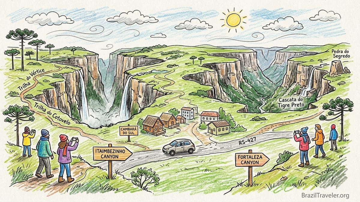
Planning a Two-Night Base in Cambará do Sul
Cambará do Sul in northern Rio Grande do Sul is the natural base for visiting both the Itaimbezinho canyon in Aparados da Serra National Park and the Fortaleza canyon in Serra Geral National Park. The town sits roughly 200 kilometers from Porto Alegre by road and feels more like a windswept plateau town in Patagonia than the Brazil of coconut palms and beach kiosks. Daytime temperatures during my May visit hovered around 12 to 16 degrees Celsius, and the wind on exposed viewpoints cut right through light clothing, which surprised many travelers arriving from warmer parts of the country.
I chose a two-night stay, which I now consider the minimum reasonable time if you want to visit both canyons without rushing. On day one I dedicated myself to Itaimbezinho, hiking the Trilha do Vértice in the morning and Trilha do Cotovelo after lunch. Day two was reserved for Fortaleza, with the main rim viewpoints and short side trails. This schedule also matched the official opening pattern: at the time of my trip, the Itaimbezinho sector was closed on Mondays and Fortaleza was closed on Tuesdays, with both usually open from Wednesday to Sunday. Because closures and hours can change, I checked the latest information with the Urbia Canions Verdes concession and the ICMBio guidance before finalizing dates.
Accommodation in Cambará do Sul ranges from simple pousadas to boutique chalets. I stayed in a mid-range pousada a few blocks off the central square, paying the equivalent of a modest city business hotel in Brazil. That bought me a heated room, hot shower and a substantial breakfast of bread, cheese, eggs, fruit and strong coffee, which meant I could be on the road to the parks by 8:00 a.m. without hunting for an open café in the cold. For travelers without a car, several local agencies on the main avenue offer day tours to each canyon that include transport and guiding, but keeping a rental car gave me the flexibility to adjust plans around fog and rain.
Before arrival I pre-booked my park admissions through the Urbia Canions Verdes system, which now manages visitor access for both Aparados da Serra and Serra Geral. In 2026, the base individual admission for foreign and Brazilian visitors was in the range of a few dozen reais per park per day, with discounts for residents of surrounding municipalities and separate parking fees. The key was that tickets were dated and often sold out on holiday weekends, so I bought mine about one week in advance once I was sure of my travel dates.
Getting to Itaimbezinho and Handling the Access Roads
From central Cambará do Sul, the paved RS-427 leads roughly 18 kilometers to the main entrance of Aparados da Serra National Park and the Itaimbezinho canyon. With an early start and little traffic, I covered the distance in about 25 minutes. The first section is fully paved and in good condition, although occasional potholes demand attention after heavy rain. The final approach inside the park concession area uses compacted dirt and gravel but is wide and flat enough for a conventional rental car. On my visit, I drove a standard front-wheel-drive compact and had no difficulty reaching the parking area in dry conditions.
At the entrance gate I presented my pre-purchased QR code and paid a modest parking charge. The concessionaire staff checked my ID, gave a brief safety explanation and reminded me that drones were prohibited without specific ICMBio authorization. Simple toilets and a small visitor center building with interpretive panels stand a short walk from the parking lot. Here I filled my water bottle from the provided taps and put on a light windbreaker, even though the morning sun looked friendly from inside the car.
Although tour operators in Cambará do Sul advertise 4x4 transfers to the parks, in the case of Itaimbezinho I did not feel a four-wheel-drive was necessary for the standard rim trails. I spoke with a Brazilian couple who had arrived in a low-clearance city hatchback that handled the access road without scraping. They had booked a 4x4 package mainly for the guiding element and commentary, not for traction. Unless heavy rain has turned the internal tracks muddy, most visitors with rental sedans or hatchbacks should be comfortable driving themselves to Itaimbezinho, which can significantly reduce trip costs.
The main reason some travelers still choose a transfer is peace of mind on unfamiliar roads and the chance to rest rather than drive after a long day of hiking. Most Cambará agencies I checked were charging in the region of a few hundred reais per person for a full-day tour to Itaimbezinho in 2026, usually including transport, guiding, and park admission, but not lunch. Self-driving couples who split fuel and admission typically spent less, at the cost of having to manage navigation and timing on their own.
Walking Trilha do Vértice: Short, Scenic and Wind-Exposed
My first trail inside Aparados da Serra was Trilha do Vértice, a short loop that leaves directly from near the visitor center. Official park materials list the route at about 1.4 kilometers total, and the staff advised me to expect 45 minutes to one hour round trip at a relaxed pace. The path begins on a compacted earth and gravel surface, quickly reaching boardwalk-style sections and fenced viewpoints as it approaches the rim of the Itaimbezinho canyon.
Within ten minutes I reached the first mirante, looking straight onto the narrow chasm where the Cascata das Andorinhas pours into the void. The canyon walls here are nearly vertical, rising several hundred meters, so much so that much of the falling water turns to mist before reaching the bottom. Even though the trail itself is classified as easy and suitable for most ages, the exposure of the viewpoints means that visitors who are sensitive to heights may feel a racing heart as they look straight down into the gorge.
Continuing along the loop, the trail alternates between open grassland and low sections of Araucaria forest. After light rain the day before, the shaded forest segments were damp and a little slippery, especially where thin mud formed over compacted soil. I was glad for sturdy trail shoes rather than smooth-soled sneakers. Several sections are protected by wooden fences or metal rails near the rim, which helped when gusts of wind came ripping up the canyon. Altogether, Trilha do Vértice has minimal elevation gain, but constant side winds and wet boardwalks demand attention from children and older hikers.
The final mirante of the loop may be the single most photogenic point of Itaimbezinho for casual visitors. From here I could see both the Cascata das Andorinhas and the taller Cascata Véu de Noiva dropping into the same stone corridor, with the characteristic “vertex” where the canyon appears to split giving the trail its name. Cloud fragments drifted through the gorge, periodically hiding the waterfall tops and revealing them again. On clear mornings, other visitors told me they had seen all the way toward the coastal plain of Santa Catarina, but on my partly cloudy day the highlight was the moody atmosphere and the roar of water far below.
Tracing the Canyon on Trilha do Cotovelo
After a quick snack at my car around midday, I set out on Trilha do Cotovelo, which offers a more extended walk along the canyon rim. Official descriptions put the route at approximately 6 to 6.5 kilometers round trip, with most of the path following a former park service road that is now closed to vehicles. From the visitor center, a gently descending dirt lane leads toward the canyon, and for the first two kilometers walking is almost completely flat on compacted earth and small gravel.
The trail earns its name from the way it follows a long curve of the canyon, like the bend of an elbow. After about 30 to 40 minutes of walking, the forest opens and the path reaches a series of unfenced viewpoints that reveal the full length of Itaimbezinho. On my visit, low clouds from the Atlantic pushed inland during the early afternoon and began to cling to the opposite rim, creating a white wall that advanced and retreated along the gorge. It was a dramatic demonstration of how quickly visibility can change here. At times I could see the canyon floor and the winding Rio do Boi far below; ten minutes later, the same view disappeared entirely in mist.
Trail difficulty remained easy, but the surface changed from compacted earth to wetter ground and stone near natural springs. Several visitors in canvas sneakers ended the walk with soaked feet after stepping through extended puddles and shallow rivulets. While the slope is mild and suitable for families, I found trekking poles useful for balance on slick patches, especially when returning along the same track after a light afternoon drizzle. There are no toilets along Trilha do Cotovelo itself, so practical needs must be handled at the visitor center before or after the hike.
I completed Trilha do Cotovelo in about two and a half hours including long photo stops. The most impressive viewpoint for me was near the natural mirante roughly two-thirds of the way along, where the canyon walls align in such a way that they seem to converge in the distance, underlining the depth and linearity of Itaimbezinho. Even in partial fog, the sense of scale surpassed anything I have seen in coastal cliffs elsewhere in Brazil. If you only have time for one rim trail, Cotovelo gives a more comprehensive impression of the canyon than Vértice, but the ideal combination is to do both, preferably Vértice first in the clearer morning light.
Fortaleza Canyon: Road Approach, Viewpoints and Weather
On my second full day, I drove from Cambará do Sul toward Fortaleza, in the Serra Geral National Park sector. The road leaves town via RS-427 in the same general direction as Itaimbezinho but branches to a long stretch of unpaved road before the park entrance. This section is the main reason some travelers prefer 4x4 transfers. During my visit after several dry days, the surface was washboarded and dusty but firm, with occasional loose gravel and shallow potholes. My compact rental car managed, although I had to drive slowly and carefully, especially in curves where washboarding could push the car sideways.
The park gate at Fortaleza works similarly to Itaimbezinho, with admission control and basic visitor information. In 2026, national-park regulations required that drones and commercial activities obtain prior ICMBio authorization, and that visitors stay on marked trails for safety and conservation. Toilets were available near the parking area but not along the rim trails. From the lot, a clearly marked path leads uphill toward the main Fortaleza viewpoint, where a broad stone and grass platform opens the first major panorama of the canyon.
The Fortaleza canyon feels wider and more open than Itaimbezinho. Instead of a single narrow chasm, this is a sprawling Y-shaped gorge with side arms and multiple ridges. The main mirante looks across a vast green bowl flanked by near-vertical rock walls. On a clear day, travelers and local guides told me it is sometimes possible to see the coastal plain and even a thin blue line of the Atlantic Ocean more than 70 kilometers away. During my morning visit, high clouds allowed good lateral visibility into the side valleys, but humidity near the coast produced a white haze toward the distant horizon.
From the main mirante, several authorized paths continue along the rim. The most popular leads toward views of the Cascata do Tigre Preto, where a river flows across the plateau and then tips directly over the canyon edge in multiple steps. The trail to this area follows grass and compacted soil with occasional rocky sections and short muddy stretches near streams. Another path climbs gently toward the Pedra do Segredo, a distinctive rock formation on a separate promontory that offers additional angles on the canyon and its side valleys. None of these rim trails required technical ability during my visit, but they involved more uneven surfaces and modest elevation gain than Trilha do Vértice, so less experienced walkers took frequent pauses.
Fog, Wind and Safety: Rim Trails vs Rio do Boi
One of the defining features of both Itaimbezinho and Fortaleza is how fast the weather shifts. On my second morning at Fortaleza, the first half-hour at the main viewpoint was perfectly clear. By 10:30 a.m., a low cloud deck climbed the canyon walls from the coastal side and rolled over the rim. Temperature dropped several degrees, the wind strengthened, and visibility fell from kilometers to a few dozen meters in less than fifteen minutes. Groups that had arrived later saw little of the canyon itself. Locals in Cambará do Sul often advise visiting canyons as early in the day as possible, and my experience confirmed this.
Safety on the rim trails is largely a matter of respecting marked paths, staying back from unfenced edges and wearing appropriate footwear. There are no handrails along long stretches of the Fortaleza rim, and even at Itaimbezinho, some viewpoints combine boardwalks with open rocky patches. After rain, the grass and rock can be as slick as ice in thin-soled shoes. I saw one traveler slip near the Tigre Preto area while stepping on wet rock to take a photograph; they escaped with only a bruise, but could easily have twisted an ankle. Carrying at least one liter of water per person and a windproof layer is sensible, even if the day begins bright and still in Cambará.
These rim walks are very different from the more committing Trilha do Rio do Boi, which explores the interior of the Itaimbezinho canyon from below rather than from above. Access to the Rio do Boi trail begins near Praia Grande in Santa Catarina, at a lower-elevation park gate, and involves multiple river crossings and long sections walking directly on wet stones in the riverbed. Current ICMBio regulations require that visitors use authorized guides on this trail, with age limits for children and daily caps on group numbers. Local operators I consulted described the route as about 14 kilometers round trip, often taking 6 to 8 hours depending on water level.
Talking with hikers in Cambará who had done Rio do Boi the day before, it was clear that this is not an extension of the easy rim viewpoints but another category of experience. They woke up before dawn for the drive, spent much of the day with water at ankle or knee height, and finished physically exhausted but thrilled. One couple paid a per-person price that included guiding, safety equipment and park permissions, amounting to a significant supplement over their self-guided rim day. For them, the cost and effort were justified, but they emphasized that anyone with weak ankles, limited mobility or fear of slippery stones should treat Rio do Boi as an optional, more demanding adventure, not as a default part of an Aparados da Serra weekend.
Guided Packages vs Self-Guided Visits and Total Costs
During my stay I deliberately mixed self-guided days with guided walks and spoke with several visitors who chose full packages. In 2026, agencies in Cambará do Sul were advertising combined tours including Itaimbezinho, Fortaleza and Rio do Boi over two or three days. A typical two-day package with transport from town, guiding on all rim trails and one canyon-bottom activity, plus admissions, often started in the low thousands of reais for two people, depending on the level of accommodation. High-end agencies offered multi-day experiences with boutique lodges and all meals that ran into several thousand reais per person.
By comparison, my self-guided rim-focused weekend looked modest. I paid for two nights in a mid-range pousada, two days of park admission and parking, fuel for approximately 120 kilometers of driving and food in town. The only guiding fee I incurred was for a half-day interpretive walk with a local naturalist on Trilha do Cotovelo, booked through a small agency whose brochure I picked up in my pousada. Their rate for a small group of up to six hikers was roughly comparable to a nice dinner for two in Porto Alegre, and I joined three other travelers, splitting the total.
Did the guided explanations materially improve the experience on the rim trails? For me, yes, but in a very specific way. On my self-guided morning on Trilha do Vértice, I admired the waterfalls and geology but could only guess at many details. Walking Cotovelo with a guide later that day, I learned the Tupi-Guarani origins of the name Itaimbezinho, the reasons why cloud forest clings to particular slopes, and how land-use patterns on the plateau have changed over time. The guide also knew vantage points where the wind tended to clear the fog first, which helped our group maximize views during a variable afternoon. For other visitors focused mainly on photos, the added value would be smaller, and they might reasonably choose to walk self-guided and rely on posted panels.
From a financial perspective, couples with their own rental car who are primarily interested in rim viewpoints and light hiking can usually save a noticeable amount by visiting self-guided, buying park admissions online and hiring a guide only for a single half-day if desired. Families with children, travelers without a car and hikers planning Rio do Boi or less-known trails may find that the convenience and safety margin of packaged tours justify the higher price, especially when river levels or road conditions are uncertain. For international visitors unfamiliar with Portuguese, a bilingual guide can also simplify logistics at gates and in town.
Facilities, Comfort and Where the Scenery Peaks
Basic facilities in both park sectors reflect their status as protected natural areas rather than theme parks. At the Itaimbezinho entrance, the visitor building offers flush toilets, simple interpretive displays and a small snack and souvenir counter, though opening times for food service are irregular on low-demand days. Fortaleza’s gateway provides toilets and limited shelter but has fewer indoor exhibits. Neither park sector had extensive indoor cafés or restaurants during my visit, so carrying sandwiches and snacks from Cambará do Sul was essential. Litter must be packed out, and there are designated trash points near the entrances.
Water availability is another important factor. While potable water was available at the main visitor buildings in 2026, there were no fountains out along the trails. I carried 1.5 liters on my person each day and refilled in town. For families walking only Trilha do Vértice, one liter per adult and a smaller bottle for each child may suffice in cool weather, but in the summer sun on exposed grassland, more is wise. Remember that much of the hiking is at around 900 to 1,000 meters of elevation, where sun intensity can catch people off guard even when air temperatures feel mild.
As for pure scenery, different viewpoints have different strengths. At Itaimbezinho, my personal favorites were the final mirante on Trilha do Vértice, where both waterfalls enter the canyon, and the far natural mirante on Trilha do Cotovelo, which conveys the full length and depth of the gorge. At Fortaleza, the main mirante delivers the classic amphitheater view, but the path toward the Tigre Preto waterfalls and the outlooks from near Pedra do Segredo give more complex compositions of side canyons and ridges. On a return visit, if clouds threatened, I would aim for Vértice as soon as the park opened to secure at least one clear waterfall view, then decide on Cotovelo or Fortaleza based on where the fog bank seemed thinner.
Cambará do Sul itself offers the comfort needed to recover after windy days on the rim. My pousada had efficient room heating, which is vital in winter when nighttime temperatures can fall close to freezing. Many lodgings light wood stoves or fireplaces in common areas on cold evenings, creating a mountain-lodge feel. Restaurants in town range from simple buffets to churrascarias and bistros serving regional dishes like pinhão (Araucaria pine nuts) and hearty soups. After talking with other hikers over dinner, I realized that nearly everyone agreed on one point: the canyons required more layers of clothing than they had expected for Brazil, even in shoulder seasons.
The Takeaway
Looking back on my two-night stay, the most important lesson is that Itaimbezinho and Fortaleza deserve to be understood as Brazil’s highland canyon country rather than as an extension of coastal or rainforest tourism. Their geology, climate and experience differ markedly from the country’s famous waterfalls and beaches. For visitors who enjoy walking but are not seeking technical mountaineering, the rim trails at both parks deliver unforgettable scenery with manageable physical demands, as long as wind, fog and rain are respected.
If I had to choose a single canyon to revisit, I would personally pick Fortaleza. The sense of wide-open space and the possibility, on clear days, of seeing from plateau to ocean create a rare feeling of scale. However, as a first-time visitor, I would never skip Itaimbezinho. Its narrow, dramatic gorge, twin waterfalls and well-structured trails make it the more iconic introduction to Aparados da Serra. What I would skip on a short return trip would be repeating Trilha do Vértice and Cotovelo on the same day; instead, I would choose one rim trail at Itaimbezinho and dedicate more time to secondary angles at Fortaleza.
Do both parks warrant separate days? In my view, yes. While some agencies sell “two canyons in one day” packages, compressing both into a single daylight window means always watching the clock and leaves little room for waiting out temporary fog. With one day per canyon, you gain the flexibility to sit quietly at a viewpoint for half an hour, waiting for clouds to clear, or to repeat a favorite section in different light. The drive between Cambará do Sul and the entrances is short enough that, with your own vehicle, you can also shift park choice at the last minute if wind direction suggests better visibility in one sector.
For couples comfortable with independent travel, a self-guided weekend with a rental car, pre-booked admissions and optional half-day guiding offers the best balance between cost and immersion. Hikers who want the full spectrum, including Rio do Boi or less-known trails, will benefit from at least one full-day guided excursion that covers logistics, safety and environmental interpretation, at higher but justifiable cost. Families with younger children might focus entirely on the rim trails, choosing short segments and frequent breaks, and may appreciate a guide’s help in pacing and keeping kids engaged. In every case, treating Cambará do Sul as the gateway to a distinct highland landscape, packing for wind and cold, and giving each canyon its own day will reward you with a national-park experience that feels unlike anywhere else in Brazil.
FAQ
Q1. How many days do I need in Cambará do Sul to see both Itaimbezinho and Fortaleza?
Most travelers should plan at least two full days and two nights, dedicating one day to Itaimbezinho in Aparados da Serra and one day to Fortaleza in Serra Geral. This allows time to adjust for fog and enjoy the main rim trails without rushing.
Q2. Can I visit the canyons with a regular rental car or do I need a 4x4?
A conventional rental car is usually sufficient for Itaimbezinho, where the access road is mostly paved with short dirt sections. The road to Fortaleza includes longer unpaved stretches with washboarding and potholes; in dry conditions I managed with a compact car by driving slowly. After heavy rain or if you are uncomfortable with rough roads, a 4x4 transfer offers more comfort and peace of mind.
Q3. Are the rim trails suitable for children and older visitors?
Yes, the main rim trails such as Trilha do Vértice and much of Trilha do Cotovelo at Itaimbezinho, and the primary viewpoints at Fortaleza, are considered easy walks with modest elevation gain. However, wind exposure, slippery surfaces after rain and unfenced edges require close supervision of children and caution from older visitors, especially near cliff rims.
Q4. Do I need a guide for Trilha do Vértice, Trilha do Cotovelo and the main Fortaleza viewpoints?
No, these rim trails can be walked self-guided by following park signs and staying on marked paths. A guide is mandatory for more demanding routes such as Trilha do Rio do Boi inside the canyon. Many visitors still choose guides on the rim trails for added context on geology, flora and weather patterns.
Q5. What is Trilha do Rio do Boi and how difficult is it?
Trilha do Rio do Boi is a long, guided trail that follows the river inside the Itaimbezinho canyon, starting near Praia Grande in Santa Catarina. It involves numerous river crossings, walking on wet stones and spending 6 to 8 hours on uneven, slippery terrain. It is more demanding than the rim viewpoints and is recommended only for reasonably fit hikers with proper footwear and a willingness to get wet.
Q6. How much should I budget for guided tours compared with self-guided visits?
Self-guided visits mainly involve park admissions, parking, fuel and accommodation. Guided day tours from Cambará do Sul often include transport, guiding and tickets for a per-person fee that can add up significantly for couples or families. Multi-day packages that combine both canyons and a canyon-bottom trail can reach several thousand reais per person, while self-driving couples who focus on rim walks typically spend considerably less overall.
Q7. What kind of weather and temperatures should I expect at the canyons?
The plateau around Cambará do Sul is cooler and windier than most of Brazil. Even outside winter, daytime temperatures at the canyons can range from around 10 to 20 degrees Celsius, with strong wind on exposed rims. Fog and low cloud frequently roll in from the coast, especially late in the morning and afternoon, which can suddenly reduce visibility.
Q8. Are there toilets, food and water available on the trails?
Toilets and basic facilities exist near the park entrances at both Itaimbezinho and Fortaleza, but there are no toilets along the main rim trails. Food options inside the parks are limited, so most visitors bring snacks or sandwiches from Cambará do Sul. Potable water is typically available at the visitor centers but not along the trails, so carrying your own supply is important.
Q9. Which canyon offers the best views for first-time visitors?
For a first visit, most people consider Itaimbezinho the essential stop because of its narrow, dramatic gorge and twin waterfalls seen from Trilha do Vértice and Trilha do Cotovelo. Fortaleza offers broader, more open panoramas and, on very clear days, distant views toward the ocean. Ideally, plan to see both and decide which speaks to you more.
Q10. Is it realistic to see both canyons in a single day?
It is physically possible to visit both Itaimbezinho and Fortaleza in one long day, especially with a private tour, but this leaves little flexibility for weather changes and makes the experience feel rushed. For a more relaxed trip with better chances of catching clear views at each canyon, it is preferable to dedicate one full day to each.